
![]()
![]()
|
|
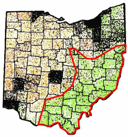
Ohio InformationBordering the south shore of Lake Erie in the US Midwest, Ohio was first was first explored by Europeans in 1669. The first settlement was near Marietta along the Ohio river in 1788. Since then, Ohio has grown to a population of near 11 million. Ohio has a strong industrial business base. Items manufactured include steel, rubber, plastics, paper, automobiles, electrical products, and electronic equipment. Raw material production include: salt, sand and gravel, coal, limestone, natural gas, petroleum, gypsum, and peat. Most of the agricultural activity is in the western half of the state. Farm products include: corn, soybean, wheat, hay, oats, potatoes, cattle, pigs, sheep, and poultry. There are about 10,000 dairy farms in the state. The average elevation is 850ft above sea level. Temperature averages: Southern ½ - Jan. 32.7 degrees F/ July 76.4 degrees F, annual avg. being 54.7 degrees F; Northern ½ - Jan. 28.7 degrees F/ July 73.9 degrees F, annual avg. being 50.9 degrees F. Precipitation: Southern ½ - 38.76"(16" of snow); Northern ½ - 36.42"(48" of snow). The land use breakdown is: Crop land 47%, Forest 26%, Pasture 5%, other including cities 22%. Ohio has been showing population increases, since the `80's, causing a building explosion where crop land has been lost to homes and shopping districts at a rate of 70 acres per day as of 1998. Ohio boasts more than 1 million acres of state parks and forests, but the only semi-remote regions are located in the south-central and southeastern sections. It is in these S and SE sections where the bulk of the state's wildlife habitat is located. Ohio is still struggling to rebuild wildlife population levels, after extreme over hunting and habitat loss which occurred before 1930. Mammals that can be found in Ohio include: mice, voles, rats, cottontail rabbit, ground hog, skunk, opossum, raccoon, squirrels, beaver, muskrat, weasels, mink, red and grey fox, coyote, bobcat, white-tailed deer, and a few uncommon black bear. Below is a land use map of Ohio. Gold dots represent crop land, each dot= 75,000 bushels. Brown dots represent animal farms, each dot= 500 head. Black dots represent human population. Green shaded area represents forest cover. The area outlined in red indicates where it is most likely a creature, such as a Bigfoot, could be found based on suitable habitat, wildlife surveys, food supply, history of reports, and degree of remoteness. We have received reports from NW and NE Ohio, but the best chance of the creature's survivability is in the marked area.
Here are the counties we have identified where hoaxes and/or misinterpretations are common.Ashtabula, Columbiana, Coshocton, Guernsey, Muskingum, and Tuscarawas counties. Land Overview and Ecological NichesOhio's topography can be generalized by gradual rolling hills of
no more than 200 foot rises in elevation in the eastern, southern, and
southeastern sections of the state. The western sections are much flatter, which
is why this section is popular for farming. The forest cover is primarily mixed
hardwoods. Generally, most of the trees are less than 75 years old. Few groves
of older trees escaped the timber industry. There is a lot of land in transition
from fields to forest, and much of this land has very dense undergrowth. The
western part of the state was heavily sculpted by the last ice age, and was once
home to a great glacier drainage river. This river cut into the land to near the
limestone layer, creating some of Ohio's only caves. These caves can
be found in the following counties: Champaign, Delaware, Highland, Logan,
Seneca, and Wyandot. The southeast section of the state escaped the effects of
the last ice age, allowing this section to retain a rougher, hillier landscape.
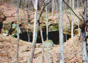
In the south central and southeastern sections, rock outcroppings are scattered
across the land. Many of the resulting rock overhangs range in size from inches
to hundreds of feet. These rock shelters consist of eroded sandstone and have no
underground chambers, and should not be confused with caves.
Many of these overhangs make good shelters for animals. No doubt, cougars used them as dens when they were common in the state in the early 1900's. In a few areas, sandstone gorges up to 200 feet deep can be seen, like at Hocking Hills State Park.
The southeastern section of the state has a history of coal mining. Large scale strip mining, since the 1930's, has permanently changed the landscape. Strip mines must now be reclaimed, meaning that the original contours of the land must be restored after the surface mining. Reclaiming will never restore the land completely, and has turned large tracts of land into grassy fields.
Before reclaiming became law, strip mining left what some called "ugly scars" on the landscape. Rock ledges up to 200 feet tall broke up the rolling hills. Hill tops were gouged out creating unique hilltop ponds. Hardly any trees were replanted, causing dense undergrowth in the now wooded areas. These areas don't allow for future human expansion, due to the rough landscape, thereby creating excellent wildlife habitats.
Even though much of the water around these strip mines is very acidic, many animals still enjoy the variety of ponds and swamps that have formed. The rock walls have created a maze of valleys and nearly inaccessible cliffs. Some of these rock walls can be over a mile in length. All of the tops of these walls are eventually accessible after you find the passages. However, this can be very difficult in the summer season due to heavy brush and poison ivy. These areas should be considered dangerous due to: falling rocks, abrupt drop-offs, rubble, and steeply banked deep waterways. We do not recommend hiking these areas. The old rock ledges are unstable, and pieces often crash down creating shelter areas for small animals. Sometimes large pieces shift away from the walls and large rocks fall between them, creating overhangs and cave-like areas large enough for a several people to fit inside. Our group has explored the tops and bottoms of many of the more remote rock walls in search of Bigfoot evidence, but have not found any yet.
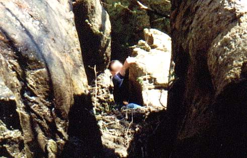
As an example of how some of these openings around old strip mine walls can provide shelter and temporary cover, see how the team member can disappear in the below pictures.
Outside the old strip mine areas is the normal Ohio landscape. The areas near these strip mines create a unique wildlife habitat. Inside the strip mine areas, dense cover is found. Outside the strip mines, forests and farms contain excellent food sources. This habitat suits many of the animals native to the region.
Some of the areas near old strip mines have a high incidence of
Bigfoot reports. The next two pictures are an overview of areas that has had a high
number of Bigfoot reports over the last 20 years. It is interesting to note, the
area is near the combined habitat of: old strip mine rock walls, reclaimed strip
mines, major waterways, and farms.
What Does All This Mean For Ohio BigfootWe don't mean to infer from the above that Bigfoot lives in caves or cracks in rock walls. It just is information concerning environmental niches that aren't often thought of when thinking about Ohio. We can say that the majority of historical reports occur in the unglaciated parts of Ohio that do have rock overhangs, open old coal shafts, and other similar cover. It should be noted that most animals use some type of cover during inclement weather and as temporary housing. If Bigfoot does exist in Ohio, there is certainly some room for it. The strip mine areas do offer excellent seclusion, but are rather small and do see some human activity. After all, some of these areas are public hunting areas. Only 10% of the counties have a population density of less than 50 people per square mile. Even these areas can not be considered as remote, because there is human activity present for at least part of the year. Hunting, mushroom collecting, hiking, camping, fishing, and biking are all common activities. If large creatures did inhabit the area, there would be far more real evidence found and credible sightings reported. By comparison, the small number of bear in Ohio are often seen and reported. Many local Bigfoot "researchers" do claim to find evidence, but the evidence found so far is incapable of proving the existence of Bigfoot in Ohio. There are witnesses out there that are seeing something, and we would certainly like to hear from more of them. Ohio's less remote habitat offers one important advantage to Bigfoot research; reports can be more thoroughly and rapidly investigated resulting in a much greater chance of obtaining suitable evidence. If the creature is real, proof should be readily found; if the creature does not exist, the lack of proof may speak for itself. Since 2002:
|
 Here is an example of a 25 foot wide
rock overhang.
Here is an example of a 25 foot wide
rock overhang.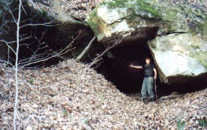 Another example of a overhang that would provide cover, this one is 15 feet
deep.
Another example of a overhang that would provide cover, this one is 15 feet
deep.
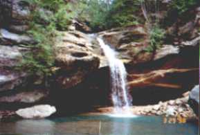 A waterfall at Hocking Hills
State Park in Hocking County.
A waterfall at Hocking Hills
State Park in Hocking County.
 Reclaimed strip mine.
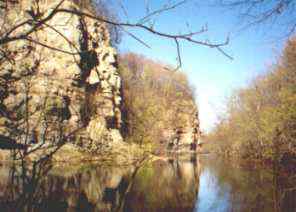 An example of a strip mine rock
wall and associated waterway.
An example of a strip mine rock
wall and associated waterway.
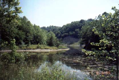 Another example of a recovered
strip mine pond loaded with fish and frogs.
Another example of a recovered
strip mine pond loaded with fish and frogs.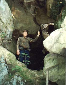 A team member inside a
10'x15'x12' shelter that formed between two rock walls. We found an old rain
suit and some evidence that someone may have camped inside here at least once.
A team member inside a
10'x15'x12' shelter that formed between two rock walls. We found an old rain
suit and some evidence that someone may have camped inside here at least once.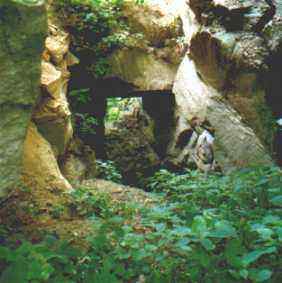 Looking down at the shelter between rock walls.
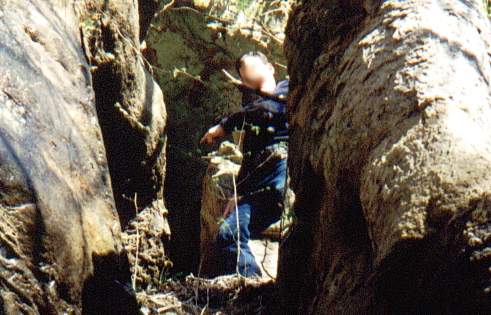 Team member pointing to a small
opening in a rock wall.
Team member pointing to a small
opening in a rock wall.
 Here the team member descends
into the opening.
Here the team member descends
into the opening.
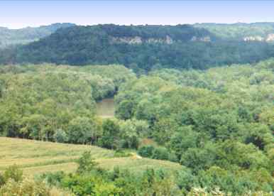 An overview of an
area near strip mine county.
An overview of an
area near strip mine county.
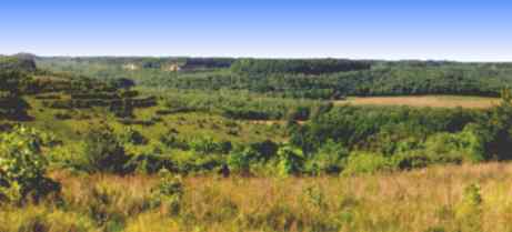 Ohio's alleged Bigfoot country?
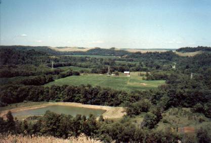 Farmland that has
had a history of Bigfoot reports.
Farmland that has
had a history of Bigfoot reports.